Coordinates
Contents
Displaying Coordinates
Pressing F3 (or Fn+F3 on Macs and some laptops) brings up a debug screen with various data—including your current coordinates, at the top left of the screen.
Interpreting Coordinate Numbers
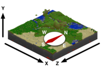
Coordinates numerically represent your location in a Minecraft world. They are based on a grid where three lines or axes intersect at the origin point.
- the x-axis indicates the player's distance east (positive) or west (negative) of the origin point—i.e., the longitude,
- the z-axis indicates the player's distance south (positive) or north (negative) of the origin point—i.e., the latitude,
- the y-axis indicates how high or low (from 0 to 255, with 140 being sea level) the player is—i.e., the elevation,
thereby forming a right-handed coordinate system (thumb=x, index=y, middle=z), making it easy to remember which axis is which.
Additionally, the f number in the debug screen tells you which direction the player is currently facing. 0 equals due south. Thus:
- 0 = South
- 1 = West
- 2 = North
- 3 = East
The origin point marks the zero point for the x and z coordinates. Hence, it may be thought of as the 0,0 coordinate:
- x-axis = 0
- z-axis = 0
As you travel south, the z-axis number increases; travel north and it decreases. Similarly, the x-axis number increases as you travel east and decreases as you travel west.
One coordinate number equals one block. And, in terms of real-world measurement, one block equals 1 cubic meter.
As your elevation rises, the y-axis number increases, and as your elevation lowers, that number decreases.
Coordinate Usage
Coordinates may be put to a variety of uses.
Once players establish bases, they should note their coordinates before going exploring. If they get lost or respawn they can find their way back to their bases by walking to those coordinates.
Coordinates are often used when sharing level seeds to give directions on where to go to find things.
Latitude
Ambient Temperature calculations are such that the average temperature at a given latitude will be similar to the same latitude in degrees north of the equator in a continental (ie non-coastal) location of North America. This results in world generation similar to that of the real world, with deserts near the equator, and arctic near the poles.
Longitude
Longitude does not affect anything.
| Navigation | |
|---|---|
| Construction | Barrels • Blueprints • Bricks • Firepit • Plank Blocks • Protection Meter • Quern • Smooth Stone • Straw & Hide Bed • Support Beams • Thatch |
| Environment | Altitude • The Player • Calendar • Cobblestone • Logs • Mobs • Saplings • Seasons • Stone • Temperature • Trees |
| Food | Agriculture • Animal Husbandry • Berries • Fruit Trees |
| Materials | Charcoal • Coal • Double Ingots • Double Sheets • Flux • Gems • Gunpowder • Hides • Ingots • Leather • Lumber • Minerals • Pottery • Redstone/Powders • Sheets • Sticks • Straw • Unshaped Metal • Wool |
| Metalworking | Alloys • Anvils • Armor • Bellows • Blast Furnace • Bloomery • Tool Molds • Crucible • Forge • Gold Pan • Metals • Ores • Sluice |
| Tools & Weapons | Arrows • Axe • Buckets • Chisel • Firestarter • Flint & Steel • Hammer • Hoe • Javelin • Knife • Mace • Pickaxe • Prospector's Pick • Saw • Shovel • Sword • Scythe • Shears • Spindle |
| Other | Crafting Differences • Item Index |
